All roads come with some worry. Or maybe it’s that worry is a kind of road. Traveling interstate highways at fast speeds has seized me with worries about catastrophic accidents. Two-lane country roads in conservative Southern states had me anxious about having plates from a northern state. In the Mojave desert, we sailed up and down tight hills on 55mph roads that rapidly toggled visibility, topping out with trampolining momentum and bottoming out hard in washes. In large cities I worry about traffic and directions. On dark nights, I worry about falling asleep. I worry about hitting deer, cattle, and construction workers. I worry about getting pulled over. I worry about trucks and RVs and sports cars and motorcycles. I worry incessantly that I’ll have to pee and won’t be able to. Most of all, on this trip, I’ve worried about our roofbox and the load rating of our sunroof, that the box will come flying off, or that our roof will collapse at highway speeds.
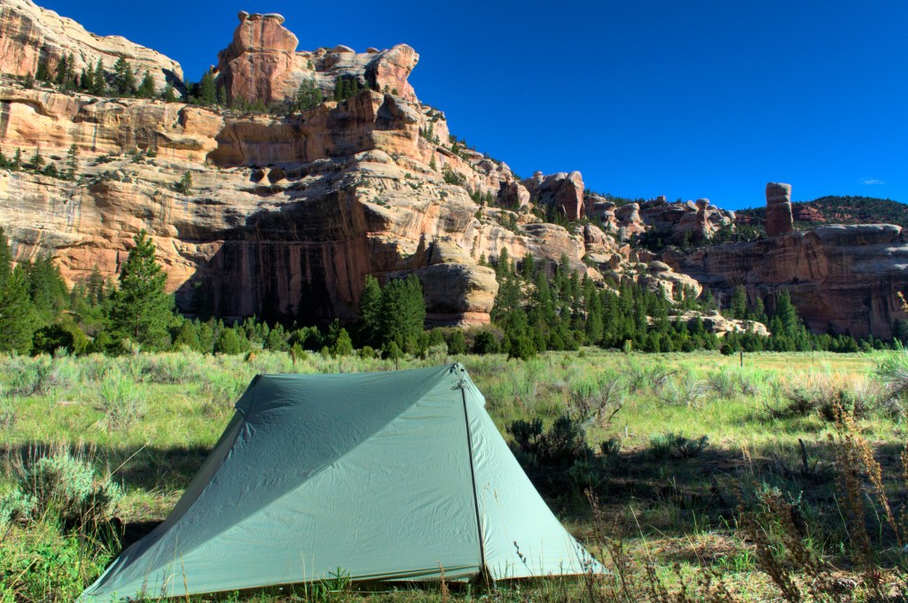
But in southern Utah, the vast networks of unpaved roads have brought a whole new league of worry. For most of my life, I’ve delighted in dirt roads. In Washington State, I would fly down forest service roads to trailheads and camps, blasting music, feeling wild. But now that we are living out of our car, I’ve become anxious. Part of it was the recommendation from a service technician in Metairie, Louisiana―probably early―that we replace our tires. Part of it is having irreparably shredded a tire on an invisible piece of debris driving the otherwise perfectly nice Dosewallips Road on the eastern side of the Olympic peninsula. Part of it is the fact that nearly a third of the information on the Grand Canyon-Parashant National Monument website―which I’d spent a fair amount of time on planning this leg―is devoted to the kinds of vehicles and tires you need to drive their roads. Whatever the reasons, we came into Utah, where dirt roads are a fact of life, with worry on my mind about our car. Those worries have met a diversity of road conditions. House Rock Valley Road, which skirts the Vermillion Cliffs National Monument, has ruts that get to be 18 inches deep. Cottonwood Canyon Road, which traverses a massive section of Grand Staircase-Escalante National Monument, is full of sharp rocks and gravel, especially on its hill climbs. Hole-in-the-Rock Road, which travels from the town of Escalante through slot-canyon country toward Glen Canyon, is teeth-rattlingly washboarded for at least 40 miles (probably more―that’s just the section we drove). Elk Ridge Road, which travels the eastern lip of Dark Canyon in Bears Ears National Monument and the Manti-La Sal National Forest, is so remote it feels like it would take days to get help if you needed it. The Moki Dugway, which we just drove today (of this first draft), offers 1,200 feet of 11% grade switchbacks on loose gravel for vertiginous, unrailed views of the Valley of the Gods below. I (or my wife) have gripped the steering wheel hard for these roads, driven slowly, dodging potholes, rocks, logs, ruts, upheavals, streams, and cattle (we actually drove, literally, through a cattle drive, complete with shirt-tucked cow herders chatting casually atop their horses in the clean air to the side of the chaos). Camping off these roads, I’d check our tires every morning, the distance into town a number I’d hold in my head. Worry has been with me ever since we got back on the road, but it hasn’t been the kind of worry I thought I was going to have.
~
I thought I was going to be worrying about coronavirus, but in Utah, the pandemic has had less presence. Many businesses remain closed, but really, there aren’t very many businesses to begin with. Our sense of “the social” has been watching a truck-trailer drive some other dirt road on the other side of the valley we are in, or hearing the whine of OHV’s on the other side of some butte, or, most social of all, chatting with the occasional hiker on a trail. There is so much wide-open and freely accessible terrain―and the culture is definitely one of self-sufficiency and spreading out―that distancing is pretty built in. The exceptions have been the few towns that service these remote lands, which on weekends we’ve seen jammed with people, milling around in parking lots or waiting in burger joint lines, and at frontcountry trailheads in some of the just-reopened National Parks, which have also been jammed, especially on weekends. In indoor settings, I’d estimate 20% of people wear masks; outside, hardly anyone at all does. We’ve been distressed, almost reflexively, to see crowds, and it has kept a pressure on us to really limit our interactions and really live, with everything we have, out of our car.

We left Yucca Valley on May 11th. Initially we had plans to leave April 30th and spend our May 1, 10-year wedding anniversary in Big Sur. Two days before we were supposed to leave the county extended the closure of the area, and the itinerary we had rebooked (after it was canceled from the first closure) was lost. So we extended our stay in Yucca for ten days and celebrated our anniversary with an elaborate home cooked meal (a “Provence Picnic” at the heart of which was actually the famed Ligurian focaccia), a bottle of mescal, and a bottle of Chateauneuf-du-Pape (one of of our go-to “treat” wines). On the remaining days of our extension we planned the ever-living shit out of southern Utah, 20 browser tabs of BLM, National Monument, National Park, National Forest, Outdoor Project, and tourism websites open at a time. Here is our driving, camping, hiking, and backpacking itinerary of Utah in list form:
1. Two nights at a road camp near Oak Grove in the Pine Mountains outside of St. George, hiking the Highline Trail there.
2. Drive through Zion National Park (just reopened the day we did it) and HWY 9 Scenic Drive, down through Kanab and toward the Arizona border.
3. Then two nights at the Stateline Campground (on House-Rock-Valley Road; terminus of the Arizona Trail), hiking Coyote Buttes South in the Vermillion Cliffs National Monument.

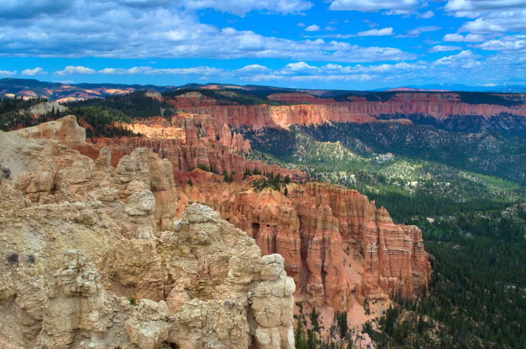
4. Drive back west and through Kanab, then up through Bryce Canyon National Park and the scenic drive there (opened the day before we did it), over the pass on Scenic Byway 12, and down toward Cannonville.
5. Two nights off of Cottonwood Canyon Road in Grand Staircase-Escalante National Monument, scrambling around the buttes and hoodoos with views onto Big Dry Valley and Kodachrome Basin.
6. Continue on Scenic Byway 12 through the town of Escalante and up onto New Home Bench in the Phipps-Death Hollow ISA WSA (astonishingly beautiful drive, perhaps the the prettiest drive we’ve ever done), down into the town of Boulder, then down the Burr Trail Road.
7. Two nights at GSENM/BLM Campground Deer Creek (first wet camp since Oak Grove, first showers (bag/solar) since we left California), exploring a little bit up Deer Creek.
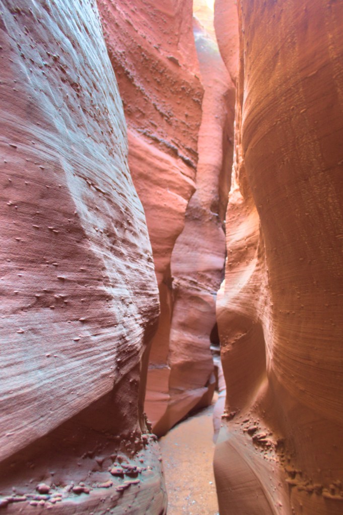
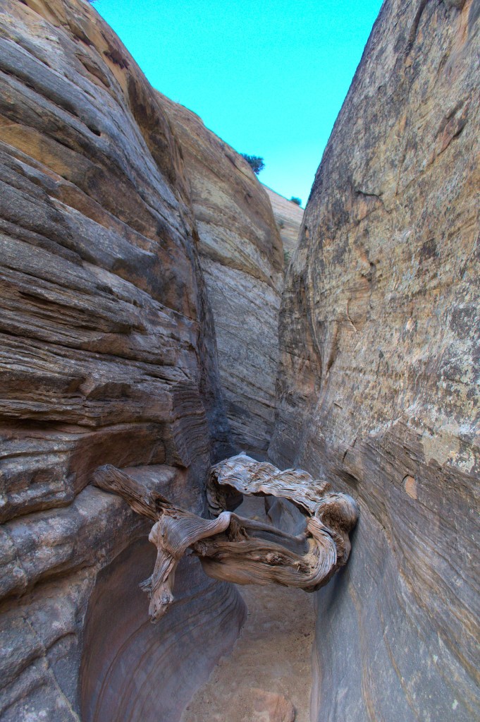
8. Back to Escalante and then down Hole-in-the-Rock Road, hiking the Peek-a-Boo/Spooky Slot Canyons loop, then onto the Red Well trailhead for Coyote Gulch. Camp at the TH (after waiting out 40+ mph winds, drinking cold beers in the car and watching the sunset).

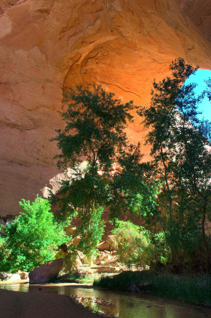
9. Two-night backpack of Coyote Gulch (thinking about all the people we would have loved to bring along on it (some nieces especially)), about a 25mi out-and-back, making it almost to the Escalante River (shy by about 1000 feet, it turns out).

10. Super fun drive out of Hole-in-the-Rock (wife sailing over the washboard; drinking roadies still cold from the cooler; forgetting about car worries), then back north through Boulder, camping one night in higher elevation National Forest camp (off FR 165 in the Dixie National Forest), enjoying the Ponderosa pines, cooler temps, and lack of bugs.
11. Continue north on Scenic Byway 12 higher into the mountains, camping again in Dixie NF at Oak Creek Campground for another night, driving down into the town of Torrey for groceries/internet/phone calls (second bag/solar showers).
12. Then up to to Capitol Reef National Park (weekend; frontcountry too busy!), doing a one-night backpack hiking east down Pleasant Creek (saw only one other party in that much more remote area, cool kids from SLC) where we camped in a wash at the mouth of a surprise slot canyon near the park boundary (when you start to see a lot of footprints, it’s sometimes worth following them).
13. Pack out of Pleasant Creek, and, now on HWY 24, head east (through remote moonscapes) then south (hooking up with SR 95) toward Hite in a sliver of Glen Canyon National Recreation Area (parade of Memorial Day weekend boaters on the road in the opposite direction).
14. Two nights at Hite Campground in the GCNRA (on Memorial Day; had the 40+ site camp nearly to ourselves; test run of a fully loaded packraft (for Alaska) on the Colorado River; first actual plumbing showers―took three).
15. Continue on SR 95 following lovely Fry Canyon into Blanding (first liquor store since California) and then Monticello; drove into Manti-La Sal National Forest and onto Elk Ridge Road, camping one night in the pretty meadows of the ridge.
16. Then a two-night backpack down into Dark Canyon, hiking to Scorub Canyon/Horse Pasture from The Notch (very remote, saw only one other party in the canyon over the two days). Hiked up into a large alcove and found Puebloan (I think) ruins.

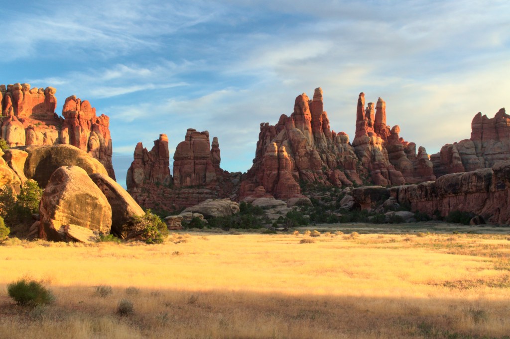
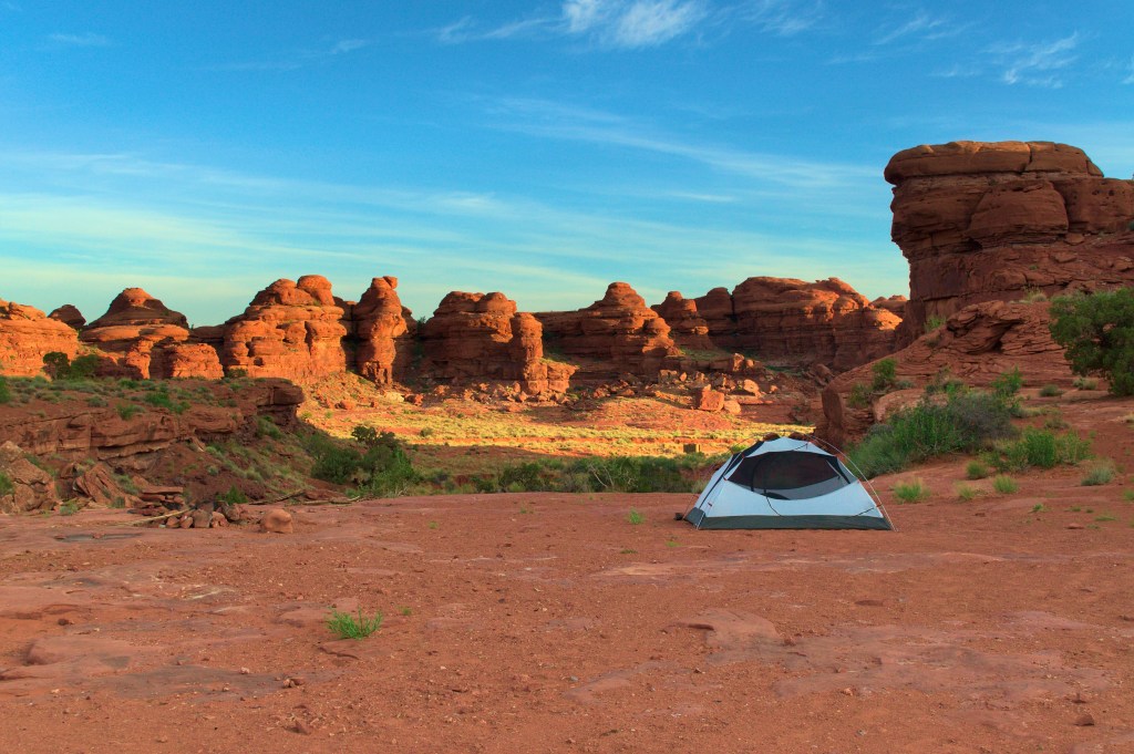
17. Drive back to Blanding and Monticello and up toward the Needles District of Canyonlands National Park through the Indian Creek unit of Bears Ears National Monument, camping one night at BLM camp Hamburger Rocks (camps tucked up against cool patty-like formations; wicked thunderstorm blew through and we had to keep our backs up against the tent wall for about an hour).
18. One-night backpack (planned two nights, ended up just hiking out second night) in Needles, camping at Devil’s Pocket (beautiful sunset over a lovely hidden meadow), doing a roughly 17mi loop around Chesler Park and up Big Spring Canyon, over continuous playgrounds of slickrock formations and variously sized canyons with some small slot sections; 95+ degrees and full water carry (35lb packs) had us zapped.

19. Hiking out we met some other hikers who told us about some potholes on Indian Creek just past Hamburger Rocks; found them and delighted in a refreshing swim, jumping 12 foot overhangs into the deep swimming hole; beautiful dispersed camp nearby on the lip of a small drainage overlooking the lower creek valley.
20. Back to Blanding (maybe we should we live there), charmed by (now open) information center staff person who suggested the Valley of the Gods; drove there and stopped in Bluff for Navajo Tacos (first restaurant meal in two months); got to Valley of the Gods, skirted it, then went up the Moki Dugway; made a bad choice to keep heading north to hookup with 95 again, an unplanned two-hour detour on what was supposed to be a straight-drive day to Durango, CO (sorry again to my wife).
21. Arrive into a just reopened Durango for hotel showers and awesome Himalayan food takeout (The Silence of the Lambs just starting on HBO―weird choice, maybe, but so good!)
Most of that time we had no cell or internet service, and coming back online (especially in Blanding) was, as it was when the coronavirus shutdowns were escalating in March, unnerving. There is nothing I can write that is adequate to the outrage of this moment, the murder of George Floyd, especially, but also as a necessary recognition of the ongoing violence against the black community and the shameful continuity of historic, systemic, and institutionalized racism. My wife and I, like many, have had long conversations in our camps about the pieces that are needed, police reform, criminal justice reform, more just economic initiatives, and, especially, more just educational systems and family and community resources. These are recapitulations of conversations we’ve had for years, having lived so long near imperiled black communities in Chicago, and when I was in academic publishing there, I grew somewhat close to the ideas of sociologist Loic Wacquant, who has argued that many blighted urban communities (“ghettos”) are inherently punitive and carceral states, one’s that, as he argues, produce race, the stigmatized marks of race―in a word, that police violence against black men is part of a horrific racist cycle that is woefully, deeply entangled in our national culture. His sophisticated but sensible theories, and adjacent research on things like early childhood education, economic justice, and proper community investment, help outline the complexity of the problems that need solving. In my former life, I did work that at least contributed to seeing some of these problems, and my wife did work that built and optimized programs meant to address some of them.
On this sabbatical, we are taking a break from that work, and now, that feels, frankly, wrong. Seeing images of the protests―seas of people wearing pandemic masks―has been powerful. The combined moment (protest and pandemic) is extraordinary and radical, of the complexity and fluidity and force that precisely describes, it feels, our late history. Seeing these images in the parking lot of a grocery store in rural Utah feels insane. We anticipated that this year was going to be intense―for lack of a better word―but it has still surprised us with its intensity. We were hoping our trip would put us in touch with a real America, but right now we just feel far away from it, even as we are nearly in its dead center. We feel that terrible word we’ve been trying to size up: estranged.
So I search to argue in the form of my above numbered itinerary, our recreation, that some other America does exist, is ongoing. It’s summer now. Families are out doing what they can. Right now, at the little alpine lake in the San Juan Mountains where I’m writing this (next draft :)), folks are walking their dogs and blowing up inflatable kayaks, casting for Colorado River Cutthroat all along the lakeshore. It’s perfectly idyllic. And in Utah we met, day after day, the most beautiful panoramas, the most fascinating geological presences. The swirls and buttes and hoodoos and perfect red sands of Coyote Buttes evinced an epic sculpture gallery architecturally elaborated with hidden platforms and walls and catwalks. The tight and insanely fluid curves of slot canyons are the earth in its most precise and elegant directives, a kind of pure touch (like walking the curve of a ceramic bowl) of refined geometry, their occasional chambers feeling like sudden, illuminated secrets. The alcoves of Coyote Gulch, and the immaculate echoes they throw back, feel like material manifestations of time itself, the imprint of dreaming millennia of flowing water. And the Needles are so dense it boggles the mind: land, place, and direction are all in such upheaval one becomes convinced of an alternate universe of design, an entirely different visual order. America is large and still teems with surprising beauty.
But my sense, with all this beauty, is that it stands apart. It is of itself and not for anyone. These are also very hostile places. The sun and wind were nearly unrelenting. Fleas, mosquitoes, and biting flies found us just about everywhere. Water was extraordinarily scarce. Routes were poorly marked, if at all (should we walk in the creek, up the deep sand hill, or bushwack the thick brush?). It is rugged, and we had to live and move ruggedly to get through it. Our parents had asked us if we were anxious traveling with coronavirus, and we had to be honest that we were more anxious about water sources and keeping ourselves and our gear reasonably clean. For days the best we could do was wash our faces, arm pits, and groins from water bottles. Sand blew constantly into our tents and on our bedding, clogging our zippers and stinging our eyes. The upside is that we were self-sufficient, could stay mostly clear of crowds, spend little time in indoor places, and keep our impact extremely low.
I’ve been trying to understand how whatever skills or knowledge or insights we’ve gained from these experiences might apply to the larger social crises the world is in. I think we’ve been, in a purposeful way, engaging some Rousseauian idea of a self-sufficient American, hearty independence in wild environments. These ideas are inherent to the American West, and for myself, I’ve cherished them as means to an interaction with nature that has always, since my childhood, given me something (and something to take into the social world) that nothing else can. But right now I don’t know what that thing is. Which is not to say giving up on it is any better. I have urges to join protests, get back online, start being part of other people and their projects again―but I have too many questions, too many suspicions, about how it all works right now. Part of it, absolutely, is mass and social media, and one thing I’m more certain of is that whatever form my life takes after our travels, its mediatized elements will be dramatically altered. I don’t know if that’s helpful, and I don’t know how to stay engaged in the discourses and work we need to bring our society to the place it should be (the place it is criminal, at this point in history, not to be), but I have to believe there is a way that doesn’t constantly, instantly, vertiginously leverage those discourses toward commercial or social gain (this being, primarily, my sickness with media). What can I find in nature that is worthwhile to bring back to our togetherness, our estranged togetherness? We’ve made it to the mountains. I still hope I can find out.
View a full set of photos from this leg here: https://www.amazon.com/photos/shared/8URZ_YrpQ9uiDzTh-Njtmg.gIld3JPAfbFZ1vMBBB-J1c
—Little Molas Lake, San Juan Mountains, CO, June 7, 2020
